 |
| The Brooklyn Bridge |
The Borough or Island of Manhattan (these are not quite the same) is a very densely populated metropolitan area which forms the very heart of the great City of New York. It stands to reason that there should be a myriad of high capacity means of transporting people and goods to and from Manhattan. New Yorkers rely on the various bridges, tunnels, ferries, passenger ships, watercraft, helicopters, aqueducts, pipelines and a tram for these vital means of transportation. Other than watercraft, bridges have represented one of the earliest and most cost effective ways to transport people and goods to and from the Island. Depending upon the technical definitions of what constitutes a "bridge" and which definition of Manhattan you use, there are currently no fewer than 23 existing bridges.
Given that Manhattan is an Island, it is naturally surrounded by a number of waterways. These include: the Hudson River, the East River, the Harlem River, and the Spuyten Duyvil Creek, which was replaced by the Harlem River Ship Canal starting in the late 19th century. The least known and understood of these is the Spuyten Duyvil Creek, which was, in fact, a tidal strait that flowed above the lowland separating The Bronx from Manhattan at the very northern tip of Manhattan. This was caused by the difference in the water levels between the Hudson River and the Harlem River which, in turn, was caused by the idiosyncrasies of the massive tidal movements of Long Island Sound upon the East and Harlem rivers.
Very few New Yorkers are really cognizant of the history and chronological development of all the bridges over these various waterways, and certainly not aware of the bridges that preceded the current ones.
We are limiting ourselves here to the bridges that cross the waterways surrounding the island, not the bridges where both ends are within Manhattan, except, of course, for the
Broadway Bridge, which, for reasons noted below, is included here. While the other Bridges of Manhattan are important and should be covered, we felt that these major bridges should be covered here.
At the blog
Stuff Nobody Cares About there is a
post about the existing and proposed bridges of New York (Manhattan) taken from the January 1, 1911 edition of the New York Tribune that readers will find very entertaining.
The following is a chronology of the building of the bridges of Manhattan, some of which no longer exist, in the order in which they appeared.
The King's Bridge
The earliest recorded bridge onto the Island of Manhattan was built in 1693 by Frederick Phillipse (of the Phillipse Manor of Westchester), a local Dutch Lord loyal to the British Monarch. It was built over the Spuyten Duyvil Creek that separated northern Manhattan from The Bronx, which was part of Westchester at that time.
The King's Bridge, as it was called, replaced a ferry crossing at the same location and was built of timbers.
Around 1713, the Phillipse family replaced the wooden span with a new, 24-foot-wide bridge with a wooden deck laid over rough stone supports. This bridge was part of the Boston Post Road in continuous service from its building until about 1917 when it ceased to be used.
 |
| Artist Rendition of King's Bridge & Inn, c. 1885 |
 |
| King's Bridge c. 1885 |
The bridge is said to still be in place, having been buried when the creek bed was filled in after the construction of the Harlem River Ship Canal. This bridge would have been a few blocks to the north of the current
Broadway Bridge at 230th St. The
Broadway Bridge crosses the Harlem River Ship Canal which was dug to replace the Spuyten Duyvil Creek and allow larger ships to traverse from the Harlem River over to the Hudson River.
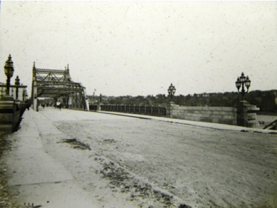 |
The Old Broadway Bridge, just before it was floated down the Harlem River
to construct the University Heights Bridge from it (see below) c. 1885. |
The old Spuyten Duyvil Creek was filled in about twenty years after the canal was created making a small piece of land that was formerly part of Manhattan Island (Marble Hill) part of the of the mainland. Note that Marble Hill, while still separated from the Island of Manhattan is still part of the Borough of Manhattan.
The Dyckman Bridge
The
Dyckman Bridge (or
Dyckmans Bridge or the
Farmer's Free Bridge or
William's Bridge) was constructed in 1759 by Jacobus Dyckman and Benjamin Palmer as a toll free bridge crossing the Spuyten Duyvil Creek near the
King's Bridge as a protest to the tolls collected on the
King's Bridge. Both The
King's Bridge and
Dyckman Bridge were used by George Washington when he retreated from the Battle of Harlem Heights on his way to White Plains. The British destroyed the
Dyckman Bridge by burning it down during the Revolutionary War in 1776, but it was quickly reconstructed.
 |
| Dyckman Bridge, c 1885 |
This bridge served New Yorkers thereafter until the early 20th century when it was finally abandoned or destroyed when the Spuyten Duyvil Creek was filled in after the construction of the Harlem River Ship Canal.
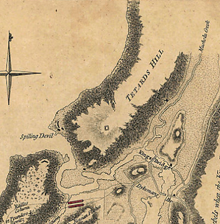 |
This 1776 map of Northern Manhattan clearly shows King's Bridge
and Dykemans Bridge. Note the lowlands to the south that would
eventually be used for the Harlem River Ship Canal to allow
better navigation between the Hudson River and the Harlem River |
The Coles Dam (or
Coles Bridge)
In 1790 the New York State Legislature enacted legislation permitting John Coles and Lewis Morris to construct a dam type bridge across the Harlem River from Manhattan Island to The Bronx. Construction proceeded and by 1797 the dam with its roadway atop was completed. It was commonly referred to as the
Coles Dam. The structure included a drawbridge and lock to allow navigation in the river. It was located where Third Avenue reaches the Harlem River. The Coles Dam was eventually replaced by the
Harlem Bridge in 1868, which was again replaced by the
Third Avenue Bridge in 1898 and again in 2002.
Macombs Dam
The next structure to have been built to allow transportation onto the Island of Manhattan was
Macombs Dam in 1816 (construction started in 1814). This dam allowed for pedestrian and carriage traffic to cross the river to and from The Bronx. The dam had a lock to allow navigation of the river through the dam. (See Currier & Ives print of
Macombs Dam below) The dam was removed starting in 1838 (see this interesting
article if you want to know more about why) due to the fact that the dam impeded the traffic on the river too much.
The Park Avenue Rail Bridge
The next bridge recorded to have been built was completed in 1841 and was located where what is now called the
Park Avenue Bridge is located where Park Avenue meets the Harlem River. The bridge was built as a railroad bridge crossing into The Bronx by the New York and Harlem Railroad (this railroad eventually morphed into the New York Central Railroad, which became part of Metro North after the New York Central went bankrupt). There have been four distinct structures built on this same site, each replacing the previous one to accommodate either heaver loads on the bed of the bridge or allowing for larger shipping traffic upon the Harlem River below. It continues today as the
Metro North Rail Bridge bringing commuters and Amtrak trains to and from Grand Central Terminal. The current structure was built in 1956 and is a vertical lift bridge made of steel. The total length of the bridge including the ramps is 1105 feet and is maintained by the MTA.
The High Bridge
Started at approximately the same time as the
Park Avenue Bridge in 1837,
The High Bridge was completed in 1848. John Jervis designed and supervised the construction of
The High Bridge over the Harlem River at 175rd St. in Manhattan to The Bronx. The bridge was part of the Old Croton Aqueduct system that was built to bring water from northern Westchester County (the Croton River). The bridge was designed like the old Roman Aqueducts with stone arches. At the terminus of the bridge on the Manhattan side a large tower was also built to store water to increase the water pressure (completed in 1872).
 |
The High Bridge on Sunday
(Harper's Weekly, August, 1885) |
The High Bridge eventually became outdated and by 1917 it ceased to carry water across the Harlem River, but continued to provide pedestrian transportation. In 1927 the center section over the Harlem River was replaced with a steel arch to permit larger watercraft vessels to travel underneath it. By 1970 even the pedestrian use ceased. The bridge is just over 1,100 feet in length and was considered a marvel of technology at the time of its construction. Since parts of the original bridge are still in place on both banks (as well as the aqueduct atop), the bridge has the distinction of being considered the oldest surviving bridge structure onto the Island of Manhattan. Today, few people know the bridge by its name and an even smaller number know the history of its use. In 2011 plans were initiated to redevelop the bridge for pedestrian and bicycle use only. On January 11, 2013 Mayor Michael Bloomberg broke ground for the redevelopment construction project which cost $61.8 Million and was reopened on June 9, 2015. The Manhattan side of the bridge and the tower are both located in High Bridge Park. The cost of the redevelopment of
The High Bridge cost about the same as the original cost to build the
George Washington Bridge.
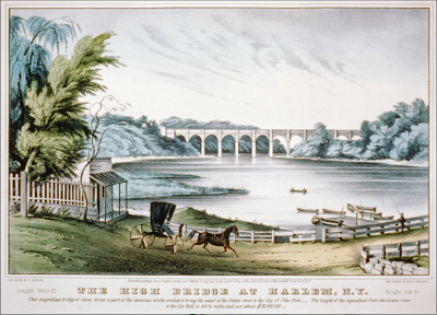 |
| The High Bridge as seen from Macombs Dam by Currier & Ives (c. 1849) |
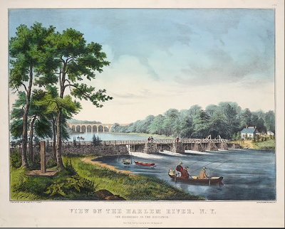 |
| Macombs Dam with The High Bridge in the Distance by Currier & Ives (c. 1852) |
The Spuyten Duyvil Rail Bridge
1n 1849 the New York and Hudson River Railroad Company laid tracks from New York City to Peekskill NY. They built a wooden trestle bridge over the Spuyten Duyvil Creek where the creek meets the Hudson River at the northern tip of Manhattan. The
Spuyten Duyvil Rail Bridge was replaced with a steel structure in 1899.
The Harlem River Bridge
 |
| The Harlem River Bridge, Harpers Weekly, 1867 |
In 1857 William McAlpine, Chief Engineer, started construction of the second bridge over the Harlem River at Third Avenue. It was called the
Harlem River Bridge (subsequently replaced by the
Third Avenue Bridge in 1898). The
Harlem River Bridge was an iron bridge onto Manhattan Island and was completed at a cost of $2,000,000 in 1865 at a height of only five feet above mean high tide. The
Harlem River Bridge replaced
Coles Dam Bridge which had come to be considered an impediment to navigation on the Harlem river.
 |
From a Stereoview photo from EH & T Anthony 3785
NY Iron Bridge Harlem River, 3d Ave.
|
The Central Bridge
 |
| Central Bridge 1861 |
In 1858, as part of the removal of the
Macombs Dam, the City of New York and the County of Westchester started the construction of the
Central Bridge at the site of the former dam bridge. The
Central Bridge was completed in 1861.
The iron-and-wood bridge featured a turntable draw with two 60-foot openings, and the 210-foot-long draw span featured a square tower design. Underneath the draw span was a main pier made of masonry. Flanking the draw span were a series of Howe trusses. The deck, which was comprised of an 18-foot-wide roadway and two 4-foot-wide sidewalks, was constructed of wooden planks. The project was engineered by Edward H. Tracy. The Central Bridge was replaced by the current Macombs Dam Bridge in the 1890s.This stereograph by E & T H Anthony shows the Macombs Dam Bridge about 1860.
The Putnam Bridge
 |
| The Putnam Bridge (aka The Polo Grounds Shuttle) |
The Putnam Bridge was a swing bridge crossing the Harlem River near the current location of Yankee Stadium above the Macombs Dam Bridge. It carried two tracks of theNew York & Putnam Railroad, and later the 9th Avenue elevated line of the IRT, as well as two pedestrian walkways.
The bridge opened to rail and pedestrian traffic on May 1, 1881. The bridge's total length was 1,004.4 feet, comprising a main span of 300 feet (the largest double-track draw span in the world at the time of construction), two identical deck truss side spans of 100 feet each, and four approach spans on either side.
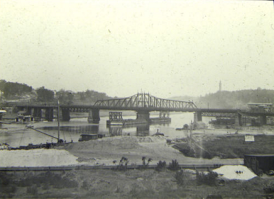 |
| The Putnam Bridge, c. 1885 |
When closed, the bridge provided 28 feet of vertical clearance, and when opened, two shipping channels of 124 feet (38 m) and 123 feet (37 m) in the east and west channels respectively.
The NY&P and its successor, the NYC&HR's Putnam Division, continued to run trains over the bridge until January 6, 1918, at which time service was cut back to a new terminal at Sedgwick Avenue, on the Hudson Division's right of way in the Bronx, and the northward-curving structure connecting the east end of the bridge to the Hudson Division was demolished. The IRT, which by then had taken over operation of the 9th Avenue El from the Manhattan Railway, reconfigured the 155th Street terminal to allow elevated trains direct access to the bridge, and on the Bronx side of the river constructed a new right-of-way, partially elevated and partially in tunnel, eastward from the bridge to a connection with the new Jerome Avenue elevated line at 162nd Street. Through service over this new line to the 167th Street station was inaugurated July 1 of that year, and extended to the northern terminus at Woodlawn by January 2, 1919.
Train service on the 9th Avenue El south of 155th Street was discontinued June 12, 1940, on the occasion of the City of New York assuming operation of the IRT; nevertheless, the segment crossing the bridge continued to be operated between 155th Street in Manhattan and 167th Street in the Bronx, as a shuttle serving the Polo Grounds. However, the New York Giants baseball team was moved from the Polo Grounds to San Francisco after the 1957 season, and the Putnam Division ceased running passenger service on May 29, 1958. These two events reduced ridership to the extent that it no longer made economic sense to continue running the shuttle, and it was discontinued August 31, 1958. The bridge's extreme narrowness of 26 feet between the centers of the trusses, combined with the presence of the Macombs Dam Bridge only a few hundred feet to the south, made it impractical and unnecessary to convert to a roadway bridge, and it was removed in 1960.
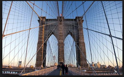
The Brooklyn Bridge
After the completion of the
Central Bridge and the
Putnam Railway Bridge, the construction of the
New York and Brooklyn Bridge or the
East River Bridge (now called the
Brooklyn Bridge) over the East River was initiated around 1867 and completed in 1883. At 5,931 feet in length with a span of 1,596 feet between the main supporting towers, the
Brooklyn Bridge was the longest suspension bridge in the world when it was built and utilized many technologically advanced innovations. It was initially designed and built by John Roebling and completed by his son, Washington Roebling, after his father's death. It is built of stone and steel and is now used for the transport of automobiles, pedestrians, and bicycles. It is a national landmark and considered an iconic structure treasured by New Yorkers.
The Madison Ave. Bridge
In 1874, residents in the vicinity asked for the construction of a bridge from `38th Street (then in Westchester) to Madison Ave. in Manhattan, and the funds were appropriated the following year. Due to the uneven topography and relatively undeveloped landscape, the proposed bridge required substantial pier and approach construction. The superstructure, composed of iron, was contracted to the Keystone Bridge Company in 1882. The swing bridge was opened in 1884 at a cost of $509,000.
The Madison Ave. Bridge would be replaced with a new bridge twice the size in 1910.
 |
| Approach to Madison Ave Bridge c. 1885 |
The Washington Bridge
Shortly after the completion of the
Brooklyn Bridge, in 1888, the
Washington Bridge was completed, which is a double arch steel bridge, connecting Washington Heights with the Bronx over the Harlem River . Designed by Hutton and Kendall, the bridge is 2,353 feet in length and is used for vehicular traffic arriving at 181st Street on the Manhattan side.

The Roaring '90s
In the next decade bridges started popping up all around the island. For the first time the swing bridge was employed. It allowed the bridge to swing out of the way for water traffic so that the bridge did not have to be constructed high above the water. Of course, the disadvantage was that there could be no traffic over the bridge while it was open for watercraft to pass. All four of these bridges are swing bridges. In 1895 the
Macombs Dam Bridge was completed with a length of 2,516 feet over the Harlem River. The same year the
Broadway Bridge was completed over the Harlem River Ship Canal.
 |
| IMPROVED RAILWAY ENTRANCE TO MANHATTAN ISLAND, NOW UNDER CONSTRUCTION, showing the new steel drawbridge over the Harlem River ship-canal and the viaduct approaches - Drawn by W. Louis Sonntag, Harper's Weekly.1895 |
This was followed by the
Third Avenue Bridge (replacing the
Harlem River Bridge) over the Harlem River three years later, in 1898, at 2,800 feet.
 |
| The Third Avenue Bridge, Harper's Weekly Magazine, February 1894 |
The next year, 1899, saw the completion of the
Spuyten Duyvil Rail Bridge over the Spuyten Duyvil Creek at the northern tip of the island at 610 feet. This span replaced the wooden structure in the same location that was built in 1849. The newer steel structure is still used today for the Metro North and Amtrak trains.
 |
Map of Northern Manhattan (1895) showing the location of the Harlem
River Ship Canal |
Interestingly, the 1898 map below of Northern Manhattan shows both the Harlem River Ship Canal and the Spuyten Duyvil Creek around Marble Hill before the Creek was filled in. Note that both King's Bridge and the Dyckman Bridge are both visible as well as the Broadway Bridge over the Harlem River Ship Canal. You should also note that there is a second bridge over the Ship Canal on what appears to be Seaman Ave., the name of any such bridge I have never seen a reference to before. If anyone knows the history here it would be greatly appreciated. The map above from 1895 does not show this other bridge.
 |
| Map of Northern Manhattan from 1898 |
The First Decade of the 20th Century
 |
THE OLD BRONX WILLIS AVE 134TH ST BRIDGE OVER HARLEM RIVER BARGES, BY RAPHAEL TUCK
|
Along with the tremendous growth of the City during this period of time we see a rapid increase in the construction of bridges. This decade saw the completion of no fewer than eight substantial bridges, four of which were over the Harlem River and three over the East River, one to Queens and two more going to Brooklyn after the
Brooklyn Bridge, and one over the Harlem River Ship Canal.
Comp. Bridge Name Type Length Crossing From
Year (feet)
1901 Willis Ave. Bridge 3,182 Harlem R. Bronx
1903 Williamsburg Bridge suspension 7,238 East R. Brooklyn
1905 145th St. Bridge swing span 1,589 Harlem R. Bronx
1906 Broadway Bridge 558 Harlem R. Marble Hill
Ship Canal
1908 University Heights
Bridge swing span 268 Harlem R. Bronx
1909 Manhattan Bridge suspension 6,789 East R. Brooklyn
1909 Queensboro Bridge double 3,689 East R. Queens
(renamed Ed Koch) cantilever
1910 Madison Ave.Bridge swing span 1,875 Harlem R. Bronx
Note that the University Heights Bridge was actually the old 1895 Broadway Bridge that was replaced and floated down to 207th Street.
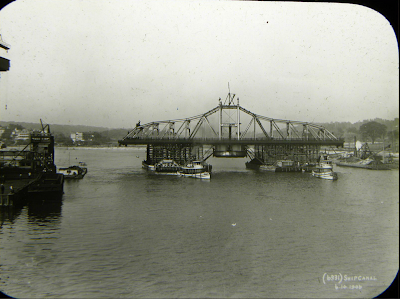 |
| Floating the Broadway Bridge down to make it the University Heights Bridge. |
Another unusual point to be noted is that until the Welfare Island Bridge was completed in 1955 there was an elevator on the Queensboro Bridge which served as the only way to allow vehicles to access Roosevelt Island.
1911 Map of Existing and Proposed Bridges and Tunnels Providing Access to Manhattan
The Proposed McCarren Bridge.
New York Tribune, January 1, 1911. Illustration showing New York City with its
existing bridges and some proposed new ones.
Sandwiched very tightly between the Brooklyn Bridge and the Manhattan Bridge connecting lower Manhattan with Brooklyn, is a proposed new bridge which was to be called the McCarren Bridge named after “Long Pat” McCarren (1847-1909) a state senator who was Brooklyn’s Democratic political boss during the late 1800s.
The Hell Gate Bridge
The only bridge built between the first decade of 20th Century and the Great Depression was in 1916 for rail traffic from Queens to The Bronx via Randall's Island which is technically part of the Borough of Manhattan. This bridge was designed by Gustav Lindenthal and traverses the East River at Hell Gate. The bridge is an inverted bowstring truss and inspired the famous Sydney Harbor Bridge in Australia of the same design.
The Lost Decades
Other than the
Hell Gate Bridge (which is entirely a rail bridge providing service between The Bronx and Queens and technically did not come onto Manhattan Island) there were no bridges completed onto Manhattan Island from 1910 until 1931. The reason is that this was the age of the tunnels. Starting in 1905 and continuing until about 1931, sufficed to say, there were at least 15 tunnels bored under the various rivers surrounding the Island to provide access for automobiles, trains and pipelines. Tunnels were far cheaper to build. We shall leave this part of New York transportation history for another day.
The George Washington Bridge
Cass Gilbert, who also designed the Supreme Court Building in Washington DC and the US Customs House in Lower Manhattan, was the architect of the George Washington Bridge which spans the Hudson River from Washington Heights to Fort Lee, NJ. Othmar Ammann was the Chief Engineer. Ammann went on to also be the Chief Engineer for the Triborough Bridge and the Verrazano Bridge. While ground breaking for the George Washington Bridge was in October 1927, the bridge was opened in 1931 and is a steel and wire suspension bridge which was the largest suspension bridge in the world when completed at 4,716 feet. It would shortly lose this title to the Golden Gate Bridge in San Francisco in 1932. However, with the addition of the lower level to the bridge, which was completed in 1962, it remains the busiest bridge in the world, carrying more vehicles on a daily basis than any other bridge in the world. The original bridge cost about $60 million. Interestingly, this is about the same amount as will be spent on the reconstruction cost of The High Bridge which is scheduled for completion in 2014 and will not carry any vehicles whatsoever.
The RFK Bridge
The Robert F. Kennedy Bridge (or RFK for short, previously The Triborough Bridge) was completed in 1936 and is actually three bridges that connect The Bronx, Queens, and Manhattan. All three spans meet on Randall's Island, which is part of the Borough of Manhattan. The three bridges are a lift, a truss, and a suspension bridge made of steel and concrete. Total length is 5,103 feet.
The Henry Hudson Bridge
This is a double deck arch bridge crossing Spuyten Duyvil at the northern tip of the island completed in 1936 from the Bronx. It was designed by David Steinman and is 2,512 feet in length. About the same time as the construction of this bridge there was yet another realignment of the Spuyten Duyvil Creek to the west of the original Harlem River Ship Canal and to the east of the
Henry Hudson Bridge. This separated a small portion of The Bronx resulting in its attachment to the Island of Manhattan as a small peninsula where the Inwood Hill Park Nature Center is now situated.
The Minor Outlying Island Bridges
In the 1950s two bridges were built. In 1951 the Ward's Island Pedestrian and Bicycle Bridge was completed over the Harlem River. It is a vertical lift bridge that is 930 feet in length. The other was the Roosevelt Island Bridge over the East River in 1955 from Queens (note that Roosevelt Island is in the Borough of Manhattan). It is a lift bridge 2,850 in length. The Roosevelt Island Bridge was originally named the Welfare Island Bridge when it was opened, but the name was changed in 1973 to its current name.
The Broadway Bridge
At the northern part of the island where Broadway extends into The Bronx the
Broadway Bridge, which is a vertical lift bridge of 558 feet, was built in 1962. It carries automobiles, trains, and pedestrians. The bridge passes over the Harlem River Ship Canal. The bridge actually does not cross into the Bronx at that point since the northern part of the bridge is in Marble Hill, which is also in the Borough of Manhattan and was only separated from the island when the canal was dug. The
Broadway Bridge replaced an earlier
Broadway Bridge. The first
Harlem River Ship Canal Bridge was built in 1895 nearby.
The Alexander Hamilton Bridge
As part of the expansion of the
George Washington Bridge which opened in 1962, the
Alexander Hamilton Bridge was built as a feeder bridge with a corresponding tunnel across the island and crossing the Harlem River to The Bronx. It is an arch type bridge of 2,353 feet in length and was completed in 1963. It is wedged between the
Washington Bridge to the north and
The High Bridge to the south.
Reconstruction of the Bridge Infrastructure of Manhattan
As with any large public works project they will need repair or reconstruction from time to time. The bridges of Manhattan have been reconstructed and replaced for hundreds of years starting with the rebuilding of the
King's Bridge exactly three hundred years ago in 1713. We note here some of the more recent bridge reconstruction and replacement projects.
In 2002 a new draw section of the
Third Avenue Bridge was put in place as well as reconstruction of the ramps on both the Manhattan and The Bronx side of the bridge. The
Third Avenue Bridge's sister bridge, the
Willis Avenue Bridge underwent a similar process of reconstruction after the completion of the
Third Avenue Bridge. The new
Willis Avenue Bridge was fabricated in upstate New York and floated to the current bridge site. Construction was completed in 2012.
In January, 2013, ground was broken for the redevelopment of
The High Bridge.
The High Bridge was reopened to pedestrian and bicycle traffic from Highbridge Park in Washington Heights to the Highbridge section of The Bronx over the Harlem River on June 9, 2015.
Randall's Island Connector
The
Randall's Island Connector is a pedestrian and bicycle bridge between Randall's Island and the Bronx that is scheduled to open in late 2015.
As a sidebar, there is an interesting article in CURBED entitled,
"Filling In New York City Rivers Was A Popular Idea In the 1800s" that would have eliminated the need for many of the bridges we now have, if the ideas were ever followed though to implementation. A good read with some interesting historical information.
Bibliography
The Washington Bridge Over The Harlem River, At 181st Street, New York City. A Description Of Its Construction By William R. Hutton (Chief Engineer), New York, Leo Von Rosenberg (pub.), 1889, 79pp. plus charts, black and white photos and diagrams.
last modified 12/28/2022


