New York City's oldest surviving bridge and newest pedestrian bridge; a site for information and a forum for those interested in its history, current activities and the future plans for the bridge, Highbridge Park, and the surrounding areas.
Sunday, June 14, 2015
Google Adds The High Bridge as a Walking Route to its Maps
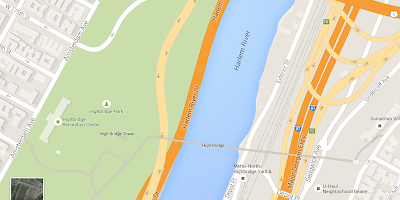
For those who want to actually use the High Bridge to get somewhere on foot or by bicycle, Google Maps has already added the pedestrian crossing over the newly opened route via the High Bridge when the trip warrants crossing that bridge (instead of another bridge) as seen in the directions shown for the trip requested above! (if you want to see it directly click here.) However, it incorrectly labels the bridge as the "Cross Bronx Expressway". Also, you still can't put the High Bridge in as your destination. Well, you can put it in as your destination, but it will direct you to the High Bridge Tower instead.
Make sure to click on the icon that you want the pedestrian route, not the auto route.
That's the way to go Google.
For those wanting correct information on how to actually get to the High Bridge please see these directions which we provided some time ago on this site in preparation of the newly anticipated demand for the information.
Editor's note:
We have received word from Google today July 6, 2015 that they have now corrected the labeling of the High Bridge and the Alexander Hamilton Bridge on their maps. See map below:
Thanks Google.
Subscribe to:
Post Comments (Atom)


Cool!
ReplyDelete