 |
| Le Pont du Gard, Roman Aqueduct, |
While aqueducts have been built since the time of the Romans, over 2000 years ago, they are still considered marvels of engineering.
There are three types of aqueducts: surface, subterranean, and bridges. While those on the surface may be the result of a tremendous amount of earth movement, nonetheless, that is where they are found. In the last century a major viable alternative for transporting water, the tunnel, has been utilized exensively. Of course, the most dramatic of all the aqueducts are the bridges that span over valleys, or other waterways.
There is also some variation in aqueducts. Some are intended to carry water for the purpose of transporting the water for more productive use elsewhere. Other aqueducts are intended to provide a means of transporting watercraft. These are oftentimes called canals. It is the canals that are suspended above the ground or dug beneath the earth that are the most unusual.
In this section we will tour some of the better known (and unknown) aqueduct bridges around the world that are still in place. Some, while still standing, do not function in their original capacity of carrying water or transporting watercraft.
Le Pont Du Gard (pictured above)
This is an ancient Roman aqueduct bridge that crosses the Gardon River in Vers-Pont-du Gard near Remoulins, Gard, France. It is part of the Nîmes aqueduct, built by the Romans to carry water from a spring at Uzes to the city of Nemausus (Nîmes). The aqueduct, while built mostly underground crosses the gorge of the Gardon and required the construction of an aqueduct bridge. Built in the 1st century, the Pont du Gard is the highest of all Roman aqueduct bridges and is the best preserved along with the Aqueduct of Segovia. .
The bridge has three tiers of arches, standing 160 feet high. The whole aqueduct descends in height by only 56 feet over its entire length of 31 miles, while the bridge descends by a mere one inch. The aqueduct formerly carried an estimated 244,000,000 gallons of water a day to the fountains, baths and homes of the citizens of Nîmes. It continued to be used until about the 6th century, with some parts used for significantly longer, but lack of maintenance after the 4th century meant that it became increasingly clogged by mineral deposits and debris that eventually choked off the flow of water.
After the collapse of the Roman Empire and the aqueduct's fall into disuse, the Pont du Gard remained largely intact due to the importance of its secondary function as a toll bridge. For centuries the local lords and bishops were responsible for its upkeep in exchange for the right to levy tolls on travellers using it to cross the river, although some of its stones were looted and serious damage was inflicted on it in the 17th century. It attracted increasing attention starting in the 18th century and became an important tourist destination. It underwent a series of renovations between the 18th and 21st centuries, commissioned by the local authorities and the French state, that culminated in 2000 with the opening of a new visitor centre and the removal of traffic and buildings from the bridge and the area immediately around it. Today it is one of France's most popular tourist attractions and has attracted the attention of a succession of literary and artistic visitors.
The Aqueduct at Segovia Spain

The aqueduct of Segovia transports waters from Fuente Fria river, situated in the nearby mountains, some 11 miles from the city. At its tallest, the aqueduct reaches a height of 93 feet. There are both single and double arches supported by pillars. From the point the aqueduct enters the city until it reaches Plaza de Díaz Sanz, it includes 75 single arches and 44 double arches, followed by four single arches, totaling 166 arches in all. The construction of the aqueduct follows the principles laid out by Vitruvius as he describes in his De Architectura published in the mid-first century.
The High Bridge
 |
| The High Bridge as seen from Manhattan looking toward the Bronx |
Since the High Bridge is the focus of this blog we will not repeat here the information you can find elsewhere on this website on this aqueduct.
The Aqueduct at Segovia Spain
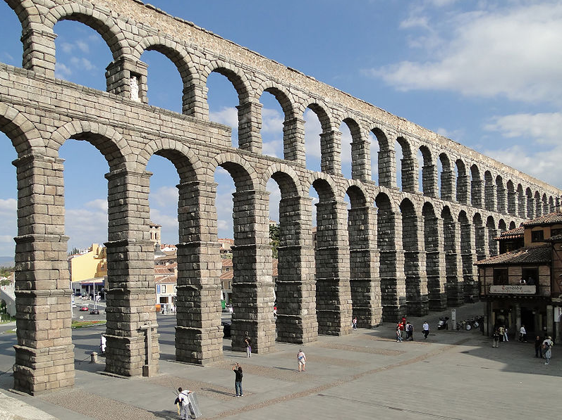
The aqueduct was rebuilt in the 15th century to restore a portion that was destroyed by the Moors in 1072. The aqueduct is built of unmortared, brick-like granite blocks. The aqueduct had been kept functioning throughout the centuries and preserved in excellent condition. It provided water to Segovia until the mid 19th century.
The Marple Canal Aqueduct
Marple Aqueduct, also known as the Grand Aqueduct, carries the lower level of the Peak Forest Canal across the River Goyt at Marple, Greater Manchester, in north-west England for the transport of barge watercraft.
The first stone was laid without ceremony in May 1794. The three arches were keyed in during 1799 and it was filled with water in 1800.

The aqueduct contains some 8,000 cubic yards of masonry and the arches are semi-circular in form and are on 72 foot centers. The lower part is of red sandstone, rough hewn from the nearby Hyde Bankquarry, and the upper part is of white-hewn masonry. The abutments widen in well-proportioned curves and batter or diminish upwards in the same manner. The skilful use of architectural features, such as pierced spandrels and string courses, arch rings and pilasters of ashlar stone, oval piers and stone of different type and color have created a graceful structure, which is superlative in its class. Its position, amidst the wooded valley of the river Goyt at Marple, gives it a bold and romantic character.
Awesome. And we get to enjoy ours again. Thanks.
ReplyDelete